
Could a Tsunami hit the British Isles?
Could a magnitude 9 earthquake and tsunami like the one that struck Japan on 11 March 2011
affect the British Isles?
The short answer is no.
Huge mega-thrust earthquakes like this only happen at plate boundary subduction zones where one of the Earth's tectonic plates is being pushed down, or subducted, beneath another.
Places where this happens include Japan, Sumatra and South America all of which have had earthquakes of magnitude 8.5 or greater in the last few years that have resulted in tsunami.
Are the British Isles close to a plate boundary?
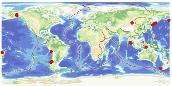
The British Isles sits in the middle of a tectonic plate, Eurasia. Our nearest plate boundary is at the mid-Atlantic ridge, where the earthquakes are too small to generate tsunami.
The nearest subduction zones to Britain lie at the Hellenic Arc, south of Greece and in the Caribbean.
Tsunami have occurred in both these regions in historic times, but did not affect the UK.
The largest recorded British earthquake had a magnitude of 5.8 and was over 65 000 times smaller than the Tohoku earthquake in Japan. Although it occurred under the North Sea it was too small to generate a tsunami.
This event is close to the maximum credible magnitude for a British earthquake. The UK experiences a magnitude 5 earthquake roughly every 25 years. These events typically cause some superficial damage.
In contrast, the Tohoku earthquake of 11 March 2011 ruptured a 400 km long segment of the plate boundary that lies east of Japan, running from the northern end of Honshu roughly south almost as far as Tokyo. East of Honshu, the Pacific plate is moving west at around 8 cm/year and is being pushed down, or subducted, underneath Japan at the Japan Trench.
The plates had been locked together for many years before enough strain accumulated to allow the fault to rupture. The average amount of slip on the fault was around 8 metres, resulting in Japan moving several metres east during the earthquake. This motion would have resulted in over three metres of uplift of the seafloor along the fault, displacing huge volumes of water and causing the giant waves or tsunami that spread out from the epicentre like ripples on a pond. The first wave took around thirty minutes to reach the coast of Japan as was followed by a number of other waves, which surged several kilometres inland.
Tsunamis and Britain
However, it may surprise many people to learn that tsunami have occurred in Britain in the past.
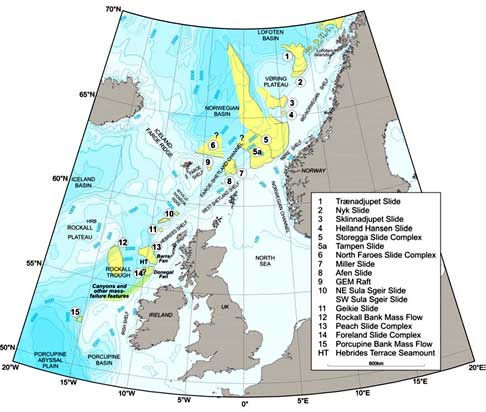
Over 8000 years ago, a massive submarine slide off the coast of Norway, known as the Storegga slide, resulted in a tsunami reaching the north-east coast of Britain.
Evidence of this can be found in geological deposits from north-east England to north of the Arctic Circle.
These show that the wave reached over 20 m above sea level at Sullom Voe, Shetland. However this quickly decreases to the south with 3–4 m in north-east Scotland and 1 m in north-east England.
A repeat of this event is unlikely, since geological models suggest that another Ice Age is needed to re-establish the conditions for a similar failure.
Lisbon earthquake and tsunami of 1755
In 1755, Lisbon was destroyed by a magnitude 8+ earthquake and tsunami.
The tsunami reached the south-west coast of England and its arrival in Mount's Bay, Cornwall was observed by the naturalist William Borlase, who described several large waves crashing against the shore over a period of two hours. The wave was also reported in South Wales and Devon.
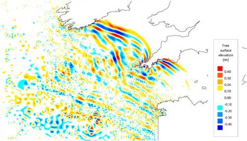
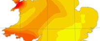
A study by BGS, HR Wallingford and the Proudman Oceanographic Laboratory commissioned by Defra looked in detail at the possible effects of another earthquake like the 1755 Lisbon earthquake.
Modelling results suggest that the wave would take around 5 hours to reach Britain, with maximum wave heights of 1–2 m around the majority of Cornwall. Such wave heights are similar to those resulting from typical storm surges that are experienced on a far more frequent basis.
Contact
Contact Brian Baptie for further information.
- A Comparison of the Folkestone and Market Rasen Earthquakes
- Seismogenesis and State of Stress in the UK
- Monitoring Volcanic Eruptions Using Interferometry
- Particular events
- Are yesterday's earthquakes tomorrow's disasters?
- Creating 'virtual seismometers' deep inside the Earth
- Is earthquake activity related to the Moon or Sun?
- Is earthquake activity increasing?