Summary
| DATE | 28/11/1880 |
| ORIGIN TIME | 17:45:00 UTC |
| LOCATION | 56.190 -5.300 |
| DEPTH | 25.0 km |
| MAGNITUDE | 5.2 ML |
| LOCALITY | ARGYLL |
| DATE | 28/11/1880 |
| ORIGIN TIME | 17:45:00 UTC |
| LOCATION | 56.190 -5.300 |
| DEPTH | 25.0 km |
| MAGNITUDE | 5.2 ML |
| LOCALITY | ARGYLL |
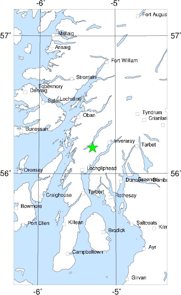

This was the largest of all recorded Scottish earthquakes, and was felt all along the west coast of Scotland, east as far as Perthshire, throughout the Inner and Outer Hebrides, and extensively in Northern Ireland. However, nowhere was the intensity very high, and the distribution of intensity was rather irregular. This is probably explained by (a) a deep focus, (b) the complex geology of the region and (c) differential attenuation across the Highland Boundary Fault. The distribution is analagous to the intensity distribution of the smaller 1976 Oban earthquake, which was also irregular - a good example of how modern macroseismic monitoring helps to understand the past. This combination of factors has lead to some widely differing interpretations of where the epicentre was (Musson 1989a). The most probable location is near Loch Awe, between Oban, Inveraray and Lochgilphead. An aftershock was felt at Inveraray.
Sources: Musson (1989b).