Summary
| DATE | 18/09/1901 |
| ORIGIN TIME | 01:24:00 UTC |
| LOCATION | 57.430 -4.320 |
| DEPTH | 11.0 km |
| MAGNITUDE | 5.0 ML |
| LOCALITY | INVERNESS |
| DATE | 18/09/1901 |
| ORIGIN TIME | 01:24:00 UTC |
| LOCATION | 57.430 -4.320 |
| DEPTH | 11.0 km |
| MAGNITUDE | 5.0 ML |
| LOCALITY | INVERNESS |
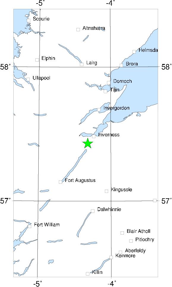

Eleven years after the 1890 Inverness earthquake a similar but larger event occurred. The felt area on this occasion extended south of the Firth of the Forth as far as Dunbar and was generally perceptible (intensity 4 MSK) in Perth and Aberdeen. There was substantial amounts of minor damage, mostly to chimney pots and plaster, in Inverness and to the south and west of the city. There were few instances of any falling masonry, though there was plenty of secondary damage caused by falling chimney pots on their way down. At least one photograph was made of the damage, now lost, though a drawing based on it survives. A long crack occurred in the towpath of the Caledonian canal at Dochgarroch, S of Inverness; this was certainly a ground effect and not fault rupture. Small amounts of damage occurred as far away as Keith.
There was a very large number of aftershocks (more than 50) and about ten foreshocks. The principal aftershock occurred about 2� hours after the main shock and may have been felt as far away as Crieff. The aftershock sequence continued until 12 November 1901.
The epicentre seems to have been at Dochgarroch. Though this lies on the Great Glen fault, this does not necessarily mean that fault was responsible; it is possible that a branch fault trending N-S was responsible for both the 1890 and 1901 sequence (and perhaps the 1816 events as well). The earthquake was not instrumenatlly recorded at Edinburgh, Paisley or Fort William - probably due to the extreme insensitivity of the instruments deployed.
Sources: Musson et al (1987).