
Coniston, Cumbria earthquake | Magnitude 3.5 | 21 Dec 2010
Last update 12.05 05/01/2011
| Date | 21 December 2010 |
|---|---|
| Origin time | 22:59 12.6s UTC |
| Lat/Lon | 54.391° North / 3.095° West |
| Grid ref | 328.91 kmE / 500.07 kmN |
| Depth | 14.3 km |
| Magnitude | 3.5 ML |
| Locality | 2 km NNW of Coniston, Cumbria |
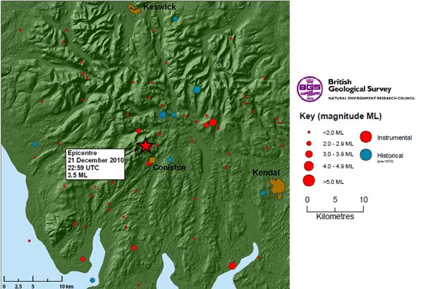
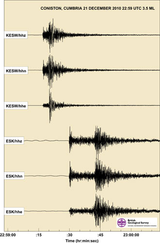
BGS detected an earthquake at 22:59 UTC on 21 December located approximately 2 km north-north-west of Coniston, Cumbria.
Many people throughout the Cumbria region have reported having felt this event. This is the largest earthquake detected in the general area since the magnitude 3.7 ML Ulverston earthquake on 28 April 2009, which was felt in the area with an intensity of at least 5 EMS.
'We get an earthquake of this size somewhere in the UK roughly every 12–18 months. Damage is very unlikely.'
'An earthquake of this size and depth might be felt up to 80–100 km away. The earthquake has probably made windows and doors rattle and small objects might have been displaced.'
Historically, the largest earthquake in recent years to have occurred nearby was the magnitude 4.7 Carlisle event that occurred on 26 December 1979 and was felt throughout Scotland and northern England with a maximum intensity of 6 EMS.
The instrumental magnitude of the earthquake at 22:59 UTC on 21 December was determined at 3.5 ML and initial reports suggested that the earthquake had been felt throughout Cumbria, southern Galloway and northern Lancashire.
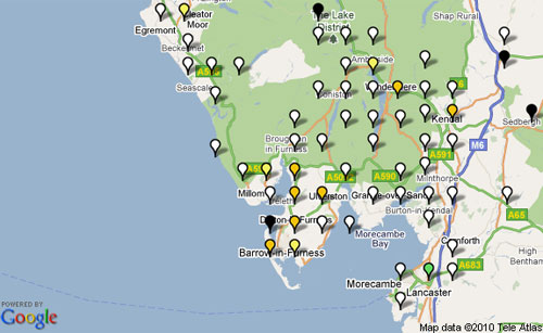
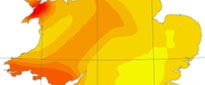
An earthquake of this size and depth might be felt up to 80–100 km away. A macroseismic survey has been launched at BGS Earthquakes. So far, the highest intensity experienced has been 5 EMS (European Macroseismic Scale), which was observed over an area extending approximately 25 km to the south and south-east of the epicentre.
Elsewhere, from more densely populated areas where more than five reports have been received within a 5 km square, the intensity has been 4 EMS; namely areas such as Penrith (about 35 km north-east of the epicentre) and Maryport, Workington and Whitehaven (about 35–45 km to the north-west).
The most credible distant reports were from the following places: to the south, the earthquake was felt in towns such as Blackpool, Fleetwood and preston (50–75 km); to the east, the earthquake was felt at Kirkcudbright, Castle Douglas, Dalbeattie and small hamlets a few kilometres north-east of Dumfries (80–90 km); and to the west, the earthquake was reported as having been felt in several hamlets in the west of the county of Durham (around 90 km).
Feedback
Comments received described the particular effects people had experienced.
Examples of comments received were:
'Felt like a very heavy truck quickly ran past the house...'
'...the whole house seemed to shake accompanied by a rumble that got louder and faded...'
'...sounded like a tank or a large lorry trundling through the cellar...'
'I felt the whole house shake and a deep rumble for about 3-4 seconds, including rattling furniture...'
'...heard the roof creek and rattle...'
'...felt and sounded like underground train under house...'
'...honestly thought that a house had collapsed or similar...'
Earthquake intensity map
Some other past earthquakes in the area
| Magnitude | UK earthquake frequency |
|---|---|
| 5 | 1 every 20 years |
| 4 | 1 every 3–4 years |
| 3 | 3 each year |
| 2 | 25 each year |
| 1 | 100s each year |
28 April 2009: 3.7 ML Ulverston
2002: magnitude 2.1 Coniston
12 September 1988: magnitude 3 Ambleside
26 December 1979: magnitude 4.7 Carlisle
9 August 1970: magnitude 4.1 by Kirby Stephen
Contact
Contact Brian Baptie for further information.
- A Comparison of the Folkestone and Market Rasen Earthquakes
- Revised Seismic Hazard Maps for the UK
- Seismogenesis and State of Stress in the UK
- Monitoring Volcanic Eruptions Using Interferometry
- Particular events
- Are yesterday's earthquakes tomorrow's disasters?
- Creating 'virtual seismometers' deep inside the Earth
- Fault line living
- Is earthquake activity related to the Moon or Sun?
- Is earthquake activity increasing?