Environmental baseline monitoring in the Vale of Pickering
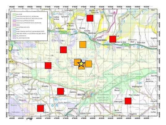
BGS, along with the universities of Birmingham, Bristol, Liverpool, Manchester and York and partners from Public Health England (PHE), has initiated an independent environmental baseline monitoring programme in the Vale of Pickering, North Yorkshire. Part of this work involves the installation and operation of a network of seismic sensors to monitor background seismic activity in the vicinity of proposed shale gas exploration and production near Kirby Misperton and where Third Energy UK Gas Limited has submitted a planning application to hydraulically fracture one of their wells.
Our aim is to collect data that will allow reliable characterisation of baseline levels of the natural seismic activity in the region. This will help discriminate between any natural seismicity and induced seismicity related to future shale gas exploration and production. Our research will help to better understand the hazard of seismic activity induced by such industrial activities and also develop ways to mitigate the risk of induced earthquakes.
Monitoring Network
The monitoring network consists of eleven stations: four borehole seismometers close to the drill site; and seven additional sensors distributed radially around the site. The borehole instruments comprise of three downhole geophones and a downhole broadband seismometer. The sensors are situated at a depth of approximately 20 m below the surface and are all close to the Kirby Misperton drill site. Installing these instruments in boreholes should improve the signal-to-noise ratio of the recorded data and allow smaller events to be detected and located. This will be particularly important for reliable detection and location of any small earthquakes that may be induced by hydraulic fracturing, as well as for the baseline monitoring.
The network is designed to reliably detect and locate any earthquakes with magnitudes of 0.5 and above across the region. In addition, it will allow us to detect and accurately locate possible induced seismicity close to the Kirby Misperton site with lower magnitudes

In general, the near-surface sensors were deployed on bedrock, since hard, dense rocks that have high seismic velocities are preferable to superficial sediments such as clays or poorly consolidated soils, which have a low seismic velocity and can act as efficient waveguides for ambient noise from cultural sources. The sites were also chosen to minimise the effect of cultural noise sources such as roads, towns and villages.
- BGS Environmental Baseline Monitoring
- Government guidance on fracking: developing shale oil and gas in the UK
- Royal Society and Royal Academy of Engineering review of the risks associated with hydraulic fracturing during shale gas exploration and production
- National Research Council, 2012. Induced seismicity potential in energy technologies, National Academies Press
- Seismological Research Letters: Special Issue on Injection-Induced Seismicity.
- British Geological Survey Shale Gas Project

