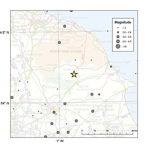
Regional Seismicity in the Vale of Pickering
We have examined both historical and instrumentally recorded earthquake activity within a 100 km by 100 km square centred on the Kirby Misperton 8 well from the BGS earthquake catalogue. This catalogue is a combination of the historical catalogue of Musson (1994) and later revisions for the period up to 1969, and earthquake parameters determined from instrumental data recorded by the UK National Seismic Monitoring Network thereafter (Musson, 1996; Baptie, 2012). It contains almost 10,000 instrumentally recorded local earthquakes from 1970 to present.
The Vale of Pickering region appears to be an area of low seismicity even for the UK with little significant recorded earthquake activity. Historically, the largest earthquake in the region was a magnitude 3.7 earthquake near Market Weighton in 1885. This had a maximum intensity of 5 EMS in the epicentral area, equivalent to shaking strong enough to cause buildings to tremble and top-heavy objects to topple. There have been a number of instrumentally recorded earthquakes in the region in the last 40 years with magnitudes in the range of 2-3 ML. These include: magnitude 2.9 and 3.0 ML earthquakes near Selby, North Yorkshire in 1978 and 1984 respectively; a magnitude 2.4 ML earthquake near Westerdale North Yorkshire in 1984; a magnitude 2.1 ML earthquake near Sledmere, Humberside in 1992; two earthquakes near York in 2003 and 2005 with magnitudes of 2.3 and 2.5 and, more recently, a magnitude 2.9 ML earthquake near Loftus, Cleveland in 2012. None of these earthquakes was within 20 km of Kirby Misperton.

References
Baptie, B., 2012. UK Earthquake Monitoring 2011/2012. British Geological Survey Open Report, OR/12/092
Musson, R.M.W., 1994. A catalogue of British earthquakes. British Geological Survey Global Seismology Report, WL/94/04.
Musson, R.M.W., 1996. The seismicity of the British Isles. Annali di Geofisica 39, 463–469.
- BGS Environmental Baseline Monitoring
- Government guidance on fracking: developing shale oil and gas in the UK
- Royal Society and Royal Academy of Engineering review of the risks associated with hydraulic fracturing during shale gas exploration and production
- National Research Council, 2012. Induced seismicity potential in energy technologies, National Academies Press
- Seismological Research Letters: Special Issue on Injection-Induced Seismicity.
- British Geological Survey Shale Gas Project

